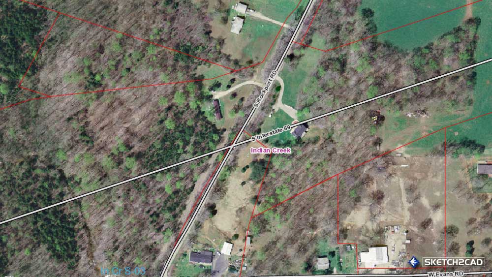
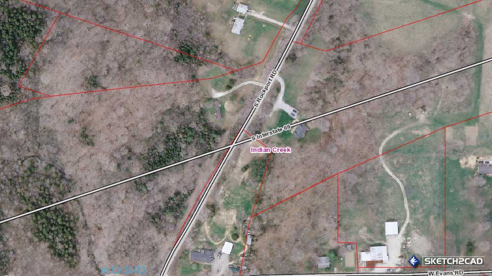
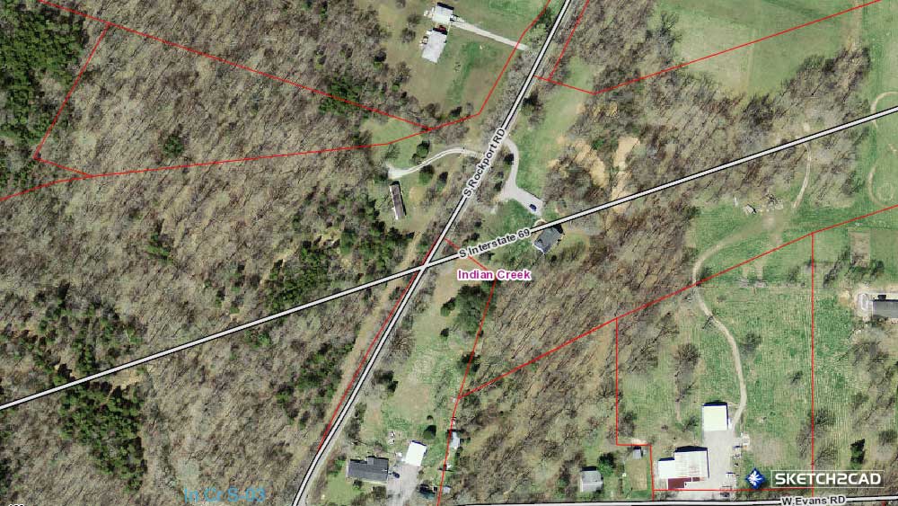
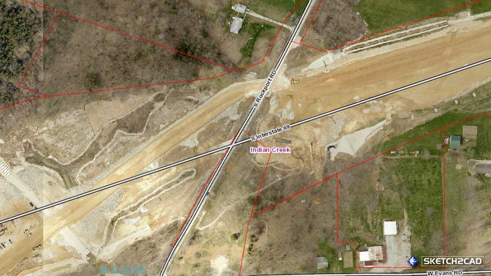
Recently, the state of Indiana finished the I-69 interstate from Evansville, Indiana to Bloomington, Indiana and currently in the process of the leg from Bloomington to Indianapolis. Throughout this construction process, you wouldn’t believe the amount of residential structures that have been demolished within the county to accommodate this mass transportation venture. While some were directly in the path of the construction, they went as far as demolishing the old barns as well that were not even close to the highway but still in the properties that they seized. While I was looking at the buildings that are now gone from the landscape forever in Indian Creek township due to the construction, I came across another home in the area that is gone but not due to the highway. Below is a loop of aerial photos from the same area showing the change in an area of Rockport Road and Evans Road of Indian Creek township of Monroe County.
In the early years of Monroe County Indiana there were little towns and villages scattered all over the place. Many aren’t even aware of these places and the main focus in our lives is the small student metropolis we call Bloomington, Indiana. There are still remains of these communities still intact around the county but not as well known. One of these little towns was named Palestine, not to be confused with Palestine, Indiana which is south of Bedford in Lawrence County Indiana. This small town was located on section #3 in Indian Creek township of Monroe County Indiana and originally owned by Isaac Withers in the year of 1816. Palestine was platted on February 17, 1845 by Thomas Shipman and founded by Alexander Sutherland which and shows up on the 1856 Monroe County plat map from my gatherings I believe the village lasted around 20 or so years. Alexander later moved to Harrodsburg and Thomas Shipman succeeded him in selling goods in the town as well as a man named Koons.

The property in question is the one currently listed as 6550 West Duvall Road in Bloomington, Indiana just northeast of the center point of section #3 above the early town of Palestine. While this property is a shot in the wind for the county, I became intrigued in finding out whom the owners were of the parcel of a forgotten early town.
The earliest map available online that shows the parcel owners is the 1856 Monroe County Indiana plat map that indicates a J. W. May owned the parcel. There are a bunch of May’s and Sare’s that live out in this area of Monroe County as shown in the image below so I am going to do my best with the information available online to interpret my findings.

J.W. May can be interpreted either as John William May or even John Wesley May in researching family trees. The person creating the plat map really handed me a bowl of spaghetti while only providing the initials. I’m not exactly sure to which the parcel was owned as John William May owned a large parcel in section #13 of Indian Creek, but that doesn’t mean he didn’t also own a tract of land near Palestine so this created a dead end for my research on him.

The next possible plat map of Monroe County Indiana is dated in 1920 which shows M. E. May owned the 117 acre tract of land which wasn’t much information to go off of considering the amount of May’s that resided in the area.

The 1932 Monroe County Plat map ‘threw me a bone’ so to speak and states that Mary E. May owns the 117 acre parcel.

The last early Monroe County Indiana plat map I have to use is the one of 1939 which lists Dovie Sare as the owner of the 117 acre parcel.

I’m going to fast forward for a brief moment and recognize the current Monroe County GIS system. While there is information about previous owners and the transference of the land from the deed records of the county, most of the people I look for is indicated as ‘Unknown’ by them as their records aren’t available. You wouldn’t believe how big the ‘Unknown’ family tree is in the community! This screenshot also provides the date that the original farmhouse was destroyed. Nice to see that the Monroe County Committees aren’t even documenting what was there and just allowing demolition , but let’s get back to the story we have at hand.
As you can imagine, just with J.W. May the name Mary May entry took me on quite a journey until I was exhausted trying to locate her. There was multiple Mary May‘s that lived in Indian Creek not in just this area from other families which makes researching some of this like a big bowl of spaghetti at times. One of the Mary May’s married a gentleman by the name of William Asbury Sare, or Ashberry depending on you records, which had a son by the name of Douglas Greensbury Sare which will show up later in this story. What I ended up doing in order to be as precise as I could be back tracking Dovie May from the 1939 map in order to find her relative Mary E. May but will try to keep all this in chronological order.
Mary Elizabeth Bowers married Augustus May and became Mary E. May shown on the maps above however I couldn’t figure out how she came to owning the land from the J.W. May name. Augustus, originally from Greene County and son of Solomon May, was a private in company D of the 14th Indiana regiment of the Civil War and was wounded at the Battle of Antietam in Sharpsburg, Maryland. Based on the architecture of the building which appears to be an early 1900’s farmhouse building I am speculating that it was the home of Augustus and Mary’s.

If you look closely to the front porch of the destroyed structure you will find a star. Many of the old farmhouses and barns of the 1800’s were adorned with these. These ‘barn stars’ had variable meanings, some of them were placed for luck and others were placed on the homes of individuals that served in the civil war.
Mary (Tonie) May married William Asbury Sare that had a son named Douglas Greensbury Sare. It took a bit of digging to locate the ‘Tonie’ portion via the census records as it only showed either Mary May or Mary T.
Augustus and Mary Elizabeth May had three daughters during their marriage: Sarah Ellen May, Laura May, and Mellissa May.
Sarah Ellen May married Douglas Greensbury Sare and had a few children one of them was a daughter by the name of Dovie Geneva Sare born on November 21, 1899. Dovie was Mary Elizabeth (Bowers) May’s granddaughter, if you aren’t confused enough yet!
During the early 1900’s Mary Elizabeth May lived in the same house with granddaughter Dovie and her parents Douglas and Sarah in Indian Creek township but passed away on September 10, 1911. The property on Duvall Road changed hands between 1932-1939 from Mary May (grandmother) to Dovie G. Sare (granddaughter), I’m not sure if Mary willed it to her directly or to her daughter Sarah and then to Dovie but it was never lived in again by the family.

Throughout Dovie’s adult life, her professional career was an employee of Indiana University as a book binder. In 1930 she lived with her mother Sarah at 339 South Euclid Avenue in Bloomington, Indiana.
In 1934 Dovie G. Sare lived at 400 South Euclid Avenue.

Finally in 1938 Dovie had moved to 517 West Howe Street.
All three of these addresses are within Prospect Hill Neighborhood of Bloomington, Indiana. These date and locations are based on the United States Federal Census records and not the Monroe County Recorder or Assessor’s records as shown on the Monroe County GIS data. Dovie and her family could have just rented these structures or they could have owned them, but without further research at the county courthouse I can’t say for certain. Being a resident of Monroe County Indiana and actually running around the streets of the Prospect Hill Neighborhood area as a young teen I always assumed that the original tenants of these buildings worked either @ the Monon Railroad or the limestone industry, go figure.
Dovie Geneva Sare never married or had children that I could find and died March 14, 1968. Many of these names in this story can be found in the two cemeteries Koontz Cemetery and South Union Cemetery located on Duvall Road that are in the area from which their families originally flourished.
Every building, either demolished or still standing, in Monroe County has a story to share. Whether the community decides to acknowledge these former residents is not known. Each and every Monroe County residents history, no matter their schooling, accomplishments, or skill, is a part of our history and should be treated as such and not forgotten because it’s not trending on Twitter or Facebook.