Below is a small collection of existing building surveys completed within the years listed above. Over the years surveying buildings has been one of the best parts of being a architectural and structural draftsman giving you the ability to examine construction methods spanning multiple generations of builders of the time. There are so many buildings that I’ve had the privilege to survey whether for current projects or just for fun. Over time, I hope to get a full pictorial of all of these buildings..if memory serves me well! Many historical facts about these buildings are available in older books, historical archives, and social media groups so I’ll try my best not to go over the same as much as possible.
2004 Existing Building Surveys

Taste of India
316 East 4th Street
Bloomington, Indiana 47408
316 East 4th Street
Bloomington, Indiana 47408
Photograph taken in 2004. This building may also be known as the old Bloomington Independent newspaper building and is a part of the city of Bloomington’s deemed “restaurant row”.

Walnut Knolls Apartments
2036 North Walnut Street
Bloomington, Indiana 47404
2036 North Walnut Street
Bloomington, Indiana 47404
Photograph taken in 2004 of the Walnut Knolls Apartment complex located at 2036 North Walnut Street in Bloomington, Indiana. The current name for the apartment facility in 2024 is State on Campus, but was previously known as Plato’s Court @ Knight’s Landing.

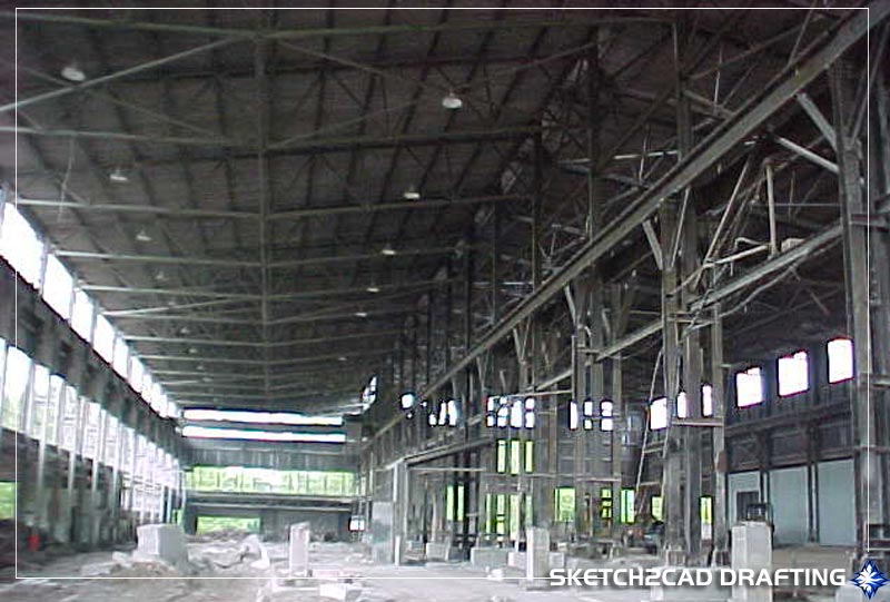
Woolery Limestone Mill
2250 West Sunstone Drive
Bloomington, Indiana 47403
2250 West Sunstone Drive
Bloomington, Indiana 47403
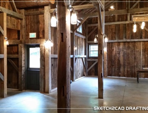
Photograph taken in 2004 of the structural remains of the Woolery Stone Mill limestone fabrication facility prior to any of the current build-outs. Construction for the mill started on May 23, 1930 and ceased all limestone production operations in 1996. Hours and hours were spent surveying this structure in order to produce an accurate set of construction plans for multiple architectural firms over the years to produce varying designs to utilize the existing historic shell.

Bloomington High School North
3901 North Kinser Pike
Bloomington, Indiana 47404
3901 North Kinser Pike
Bloomington, Indiana 47404
Photograph taken in 2022 of the Bloomington High School North (BHSN) high school. Existing structural drawings were located within the schools archives to aid in the drawing of the existing building conditions. Among many interior spaces, the entire exterior was surveyed (with all of it’s angles and corners), inspected, and detailed for repair. Being an alumni of the school years ago, I was familiar with the entire building site and layout prior to visiting the project and was nice to give back to the school that taught me how to draft in the first place.
2006 Existing Building Surveys

Church of Jesus Christ
1100 East Miller Drive
Bloomington, Indiana 47401
1100 East Miller Drive
Bloomington, Indiana 47401
Photograph taken in 2008
2007 Existing Building Surveys

Raddison
1710 North Kinser Pike
Bloomington, Indiana 47404
1710 North Kinser Pike
Bloomington, Indiana 47404
Photograph taken in 2019. This structure, formerly known as The Ramada Inn, took about a solid week of surveying and drafting to fully document all of the existing conditions for the renovation due to varying floor levels and floor plans. I still remember the owner of the facility would walk the halls periodically with his little dog Sophie and check how everything was going or if I needed anything while I worked. This was my first large existing building survey project in the Bloomington area and was eager to work on the project.
2008 Existing Building Surveys

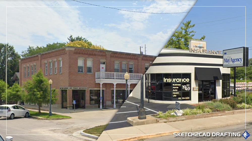
Jake’s Nightclub
419 North Walnut Street
Bloomington, Indiana 47404
419 North Walnut Street
Bloomington, Indiana 47404
Photograph taken in 2016. Over the course of this buildings life there has been quite a bit of name jumping which has made this quite a feat to figure out and still in the works.
- International Harvester
- 1950’s-1960s Barnard Motors Inc.
- 1970s-1980 Oscars
- Time Out Liquors
- 1981-1983 Jake’s
- 1994-2000 Mars
- 2006-2006 Axis
- 2006 The Walnut Street Tap
- 2006-2013 Jake’s
- 2018-2024 Switchyard Brewing
Kilroy’s Sports Bar
319 North Walnut Street
Bloomington, Indiana 47404
319 North Walnut Street
Bloomington, Indiana 47404

Photo courtesy of the Monroe County History Center
A customer entering Ye Olde Regulator Tavern “The Reg” that was on the south side of the lot in the 1970’s.
North Lot
- 1950’s Lester Nottingham’s Marathon gas station
- 19667 Turner’s Marathon gas station
South Lot
- 1965-1970s? Ye Olde Regulator Tavern
Combined Lot
- Kilroy’s Sports Bar

Photograph taken in 2016. There have been many renovations and additions to the original structure in the last decade such as the outdoor patio area that includes a covered seating area and tiki bar.
West Sixth Street / North Walnut Street
I’ll do my best to gather and analyze all the information I have to identify the buildings on the north side of the courthouse square in Bloomington, Indiana, as well as the adjacent streets, since they are all connected in some way. Countless hours have been dedicated to examining both clear and blurry photographs, following leads from various websites, engaging with local history social media groups, and having direct conversations with others. All this effort aims to piece together the history of Bloomington, Indiana, ensuring no one from the past is forgotten.
I guarantee it’ll get confusing but I will try my best attempt at it given the information available to me. Please note that the addresses on the Sanborn maps, city directories, your recollections, and the current occupant numbers are quite disorganized. I did my best to consolidate this information into a single format. There’s a lot of conflicting information, and while photographs may indicate approximate locations within the building, they don’t show street numbers.

The above map shows a current google aerial view of Bloomington, Indiana showing College Avenue, Sixth Street, and Walnut Street that will help aid in the identification of the buildings listed below.
| ID | Property # (for this only) | 2018 Occupant |
|---|---|---|
| A | 221-223 North Walnut Street | Black’s Mercantile |
| B | 217-219 North Walnut Street | The Cade |
| C | 213-215 North Walnut Street | Brother’s Bar & Grill |
| D | 211-213 North Walnut Street | B-Town Diner |
| E | 209 Walnut Street (rear of 100 Sixth Street) | Samira |
| F | 207 Walnut Street (center of 100 Sixth Street) | Samira |
| G | 205 Walnut Street (center of 100 Sixth Street) | Samira |
| H | 100 West Sixth Street | Samira |
| J | 102-106 West Sixth Street | Gratzi Italiano |
| K | 106-108 West Sixth Street | King Dough |
The above map shows a current google aerial view of Bloomington, Indiana showing College Avenue, Sixth Street, and Walnut Street that will help aid in the identification of the buildings listed below.
Building ‘A’
Black’s Mercantile
221 North Walnut Street
Bloomington, Indiana 47404

Photo courtesy of Indiana University Archives
This photograph is located on Walnut Street at the intersection of 7th Street looking south towards the courthouse. The date provided by the Indiana University Archives state 1944 which would correspond with the owner being Bert Sansone’s Fruits & Vegetables as shown by the painted wall signage on the side of the building which was fairly common at this time period. There’s also the phone number on the side of the building which is a direct number without the traditional prefix and suffix we all know today as there was not a need for it in this day. In addition, other buildings in this grouping are shown by the wall hung signage like Reeves Furniture, and Schmalz’s Department Store that helped identify occupancies of the buildings at this direct time period and will be shown later.
One of the signs are for the “Exclusive Shoppe” owned by Bertha (Rogers) Hinkle and is in the tenant space next to Bert’s store and confirmed by the 1940 city of Bloomington directory. This lady had me running all over the place trying to keep up with her because if you look at all the directories of each year between 1900-1940 you’ll see her business address is always changing. Sometimes it appears the business was in the corner building on Sixth Street, then around Schmalz’s, then across the street by the theatre, then back over by Bert’s and so forth. It’s hard to say why without really digging into her story, it may be just due to rising rent costs in the spaces (which is common) and that she was trying her best to make it on her own the best she could. At any rate she definitely took me for a ride 80 years later trying to keep up with the location of her business.
Sanborn Maps
1883-1892 (508) dwelling
1898 (223) dwelling
1907 (225) County Treasurer on north & (223) American Express on the south
1913 (225) Plumbing store on north & (223) American Express on the south
City Directory
1909-1910 (223) The Hoosier Store
1916-1930 (223-227) Fred W. Fenneman Plumbing & Heating Co.
1929-1937 (223) Dean’s Drug Store Radio Shop (north)
1938/1940 (223) Lambert Drug Store (north)
1940 (221) Exclusive Shoppe (Bertha (Rogers) Hinkle)
1946 Bert Sansone’s Fruits & Vegetables
1950s-1967? (221-223) Western Auto Association
xxxx-xxxx (221-223) Mr. Penguin Tuxedos
2005-Current (221-223) Black’s Mercantile
(Upstairs)
2008 Apartments

Photograph of the building as of 2016 as Black’s Mercantile as the current occupant. At one time, this store was the only place in the downtown area that provide the residents living in the vicinity the convenience to purchase daily necessities of life without driving to the other side of town.
Building ‘B’
I’m going to combine these occupants in this building as I’m not sure at this time what the separation was but relying only on what information I could aquire.
The Cade
217 North Walnut Street
Bloomington, Indiana 47404
Photo courtesy of Indiana University Archives
This photograph is located on Walnut Street at the intersection of 7th Street looking south towards the courthouse. The date provided by the Indiana University Archives state 1944 which would correspond with the owner being Bert Reeves Furniture as shown by the wall hung signage on the side of the building which was fairly common at this time period. In addition, other buildings in this grouping are shown by the signage like Sansone’s Fruits & Vegetables, and Schmalz’s Department Store that helped identify occupancies of the buildings at this direct time period.

Photo courtesy of Indiana University Archives
Here’s a different view of the same building at the same time period from across Walnut Street looking northwest. Most of the photographs in the archives I’ve seen were mainly taken from a large distance away from the subject building so that seeing any detail was nearly impossible. With this view you can see almost the entire northern block with each tenant occupied and their street signage even Mike’s Beer or Mike’s Cafe, depending on how it’s labeled in the directory, makes a prominant appearance here.
Depending on how you interpret the city directory and Sanborn Fire Insurance maps with each other and their building location numbers will start to confuse you. Black’s Mercantile’s current building address is (221) but back in say 1913 for instance on the Sanborn maps that space would be the addresses (225) & (223) which doesn’t exist in the current day. The city directory lables the spaces correctly as they were in the time period but trying to nail down exactly which space they were in gets confusing without more current maps than 1913 that was available online. In this 1940’s city directory, Bert’s Produce is (223) and Bertha’s is (221) but you can easily see that they are in the same building because the control joint of the limestone veneer that separates Mike’s Beer from Exclusive Shoppe.
All of the occupants of these tenant spaces are listed on this page in one way or another to the best of my knowledge, however it could be something as simple as moving them from this space to the one above but it’s all in the interpretation of it. If Bertha’s shop is moved from this entry at The Cade to the above Black’s entry in the time frame of 1938-1940 as indicated by the Sanborn maps, does that also mean that the rest of (221) comes up and integrates as well? I believe so as there’s two entries for Exclusive Shoppe, two entries for Fred Fenneman’s plumbing and it’s not a far stretch to see a barber shop move into a former clothing store. This begins the confusion trying to figure this out between the three sources of Sanborn maps, city directories and photographs as the Sanborn maps cleary show (221) & (223) in The Cade’s current building space.
People of that time didn’t have iPhone’s and Androids snapping dozens of photo’s each night taking selfies when they came out of The Bluebird and sharing it on social media. In all honesty, people didn’t really take many photos of buildings in general and was mainly personal things like family and funeral showings (as creepy as it sounds). To be able to have some of these photos is a valuable resource for the community to show the history of the community and the changes that have been made to our city over time and appreciate all efforts that have been made by the people in the community at Bloomington Restorations, Inc., Indiana University Archives, The Monroe County History Center, and the Monroe County Library.
Sanborn Maps
1883 Doesn’t exist
1887 Doesn’t exist
1892-1898 (507) Horse shed & carriage storage
1907 (221) Millinery (hatmaker) on north & (219) Barber shop on south
1913 (221) Second hand store on north & (219) Barber shop on the south)
City Directory
1916-1918 (223) Axsiom & Hendricks Second Hand Store
1909-1910 (221) Goodman & Skirvin barber shop
1920/1921 (221) Mort Owen Annex pianos
1927/1930 (221) Kroger Grocery & Baking Co.
1931-1937 (221) Fenneman Plumbing & Heating Co.
1938/1939 (221) Exclusive Shop
1920/1923 (219) W.L. Luck optician
1925/1930 (219) Koontz & Burch Furniture (north)
1931-1932 (219) Hinkle’s Meat Market (north)
1934-1939 (219) Lester Hinkle’s Cafe (north)
1940/1962 (219) Mike’s Beer & Cafe
1975?? Barzo’s Blitz
xxx-1984 (217-219) Peanut Barrrel
2018-Current (217-219) The Cade
1920-1921 (219 1/2) Hoosier Bookbindery Co./Apartment F.P.Vassie
1922-1923 (219 1/2) Apartments: J.C. Bell/A.G. Martin
1925-1926 (219 1/2) Apartments: Jones, Farr, Beade, Hill, Snoddy
1925-1926 (219 1/2) Apartments: Wylie, Loran
1931-1932 (219 1/2) Apartments: Wylie
1934-1935 (219 1/2) Vacant
1938-1939 (219 1/2) Apartments: Houston
1962 (219 1/2) Apartments: Chambers
2018 (219 1/2) Video Saloon Entrance
1920-1923 (217) A.J. Axsiom Barber Shop
1925-1926 (217) John Hupp Barber Shop
1927-1928 (217 1/2) Hupp & Burton Barber Shop
1929/1939 (217) W.R. Burton Barber Shop (south)

Photograph of the building as of 2016 as The Video Saloon (upper floor) as the current occupant. The ground floor tenant space would eventually turn from a vacant space that once housed The Peanut Barrel to what is know in 2018 as The Cade (a coin-op video arcade game/tavern).
Building ‘C’
Brother’s Bar & Grill
215 North Walnut Street
Bloomington, Indiana 47404
Sanborn Maps
1883 Doesn’t exist
1887 Doesn’t exist
1892 (506) J.F. May Livery
1898 (217) J.F. May Livery
1907 (215-217) Harness Shop ground floor/Harness Shop & Repository second
City Directory
1892/1898 J.F. May Livery
1909-1919 (217-219) Foster & Hudelson Harness & Hardware Shop
1916-1918 (215-217) Foster & Hudelson Harness & Hardware Shop
1920/1923 (213-215) Quality Hardware Co.
1925-1926 (217-219) Quality Hardware Co.
1927-1928 (217) Quality Hardware Co.
1929-1946 (213-215) Reeves Furniture
1962-2004 (213-215) McDaniel Furniture
2012-Current (213-215) Brother’s Bar
(Upstairs)
1962-2004 (215 1/2) McDaniel Furniture Storage
2004-2008 (215 1/2) Vacant

Photograph of the building as of 2016 as Brother’s Bar & Grill as the current occupant.
I remember very clearly the struggle I encountered with this existing building survey. At the time, most of the upper floors in this block of buildings were either unoccupied or random tenant spaces and somewhat interconnected. There was barely any light to illuminate the spaces which made it treacherous to navigate as if you were in some carnival fun house with all the lights shut off. Many of these spaces were painted black from wall to ceiling…or maybe it was just because there was no lights either way I’m telling you it was dark in fact it was so dark that we occasionally used the flash of the camera just to be able to see where it was to go. This was a catch 22, your pupils were dilated just to bring in as much light as they could to see and then you go and hit the flash on the camera creating a strobe effect blinding you temporarily creating ghosted images. Now there was the occasional tenant space that was on the exterior of the building which contained windows and you could just barely see light peeking from under the doorways into the rooms but it was more a less a game just trying to find your way around. The entire area of the the block of buildings was the second floor with the occasional door minus the Video Saloon tenant space. I can only imagine what the space actually looks like fully illuminated but that wasn’t in the cards for me and it was my job to somehow create a set of floor plans on the existing conditions.
Building ‘D’
B-Town Diner
211 North Walnut Street
Bloomington, Indiana 47404

Photo courtesy of Monroe County History Center
This photograph is located on Walnut Street at the intersection of 6th Street looking north towards the 7th Street during the 4th of July parade. There is no date provided by the Monroe County History Center but I’m assuming sometime in the 1940’s considering The Stardust Tap Room is shown in the neighboring structure.

Sanborn Maps
1883 Doesn’t exist
1887 Being built
1892 (506) J.F. May Livery
1898 (213) 20hp Gasoline Engine Printing on first floor/hall on second
1907-1913 (213) Grocery Store
City Directory
1920-1921 (211) S.P. Bryan Furniture
1916-1918 (213) G.A. Walker Grocery
1922-1923 (213) S.P. Bryan Furniture
1927-1988 (213) Schmalz’s Department Store
1916/1921 (213-223 Batman Block)
1980s Shangri-La Vegetarian House
Uptown Billiards Arcade & Entertainment Center
The Mirage
The Hot Spot
Club Liquid
After Hours Topless Bar
Club Cream
Ground Zero
2018-2019 Get Some Pizza!
2018-Current B-Town Diner
(Upstairs)
1916-1918 (213 1/2) Beta Phi Sigma Hall/Apartments: Hovious, Olaf
1920-1921 (211 1/2) 2 Apartments
1922-1923 (213 1/2) T.J. Wright chiropractor
1927-1928 (213 1/2 Batman Apartments) Grifin, Beade, Stevens, Heaton, Callahan, & Smith

Photograph of the building as of 2016 as B-Town Diner as the current occupant.
Buildings E, F, G, & H
Samira Restaurant
100 West Sixth Street
Bloomington, Indiana 47404

Photo courtesy of Indiana University Archives
This image has to be the jewel of all of the old photographs that I’ve ever examined in the Indiana University Photo Archives. All of the buildings on the right side have covered wood framed canopies to walk under in the hot or rainy weather, this is something that is long gone and pretty much abolished decades ago with the local planning ordinances. The road shown is made of dirt which would’ve probably been a nightmare for that poor guy on the horse drawn wagon in the rain, and this even shows the horrible ‘hump’ in the road on Sixth Street. If you’ve ever driven down sixth street you’ll notice the road slopes to the west to this day, now it’s not at this point and has been flattened out somewhat but you can still recognize it.
One thing that really boggles my mind is to think that this picture was taken in 1891 and in 117 years later I would crawling all over the roofs and within the existing buildings to measure what the builders of the that day constructed. I’m not exactly what they used to build these structures from back then but I do know that none of the paperwork still exists from that time and hopefully the hours and hours I spent surveying the actual conditions and drawing what everyone calls as ‘simple lines’ helps future generations continue the legacy of these great buildings.
According to the Sanborn maps in the year of 1891, this building on the corner of Sixth Street & Walnut Street was occupied by a grocery on ground floor & Knight of Pythias (KoP) fraternal organization’s hall on second floor. Pretty simple occupancy split right? Figuring out who is where in later generations gets a lot tougher.

Photo courtesy of Monroe County History Center
So in the 1930’s we have the Dixie Market on the first floor on the corner with what appears to me as 1930’s business trucks parked on Walnut Street facing south..yeah two way Walnut Street that’s been awhile ago. Now keep in mind I’m no automobile expert and basing these vehicle identifications solely on styles of the times.
There were also additional tenants of the building in the 1930’s. It’s stated that the Stardust Tap Room was located in the building on the ground floor on Walnut Street side which you can vaguely see and also shows up in the center of the building in the next photograph. In addition in the back of the building there was also Van Deman Cleaners Tailors and Dyers which had the wall painted signage.
There’s an image on either the IU Archives or within the Monroe County Photo Archives showing a working class man picketing the Stardust cafe out on Walnut Street next to some old 1920’s ‘gangster type’ automobiles. Here’s where some of the spaghetti of tenant confusion comes into play. I’m not sure if the Stardust Tap Room and Stardust Cafe’ are one of the same or became different entities over the years or what and which came first kind of like the chicken and the egg. The vehicles however tell a different story, the picketing man is clearly standing next to 1920’s coupe vehicles with the Reeve’s Furniture Store sign as well as the tip of the Schmalz’s Department Store sign showing that was in business between 1927-1988. The building occupants all make sense to be in the 1930’s however the picketing man’s sign says Stardust Cafe’,any insight to this would be appreciated.

Photo courtesy of Monroe County History Center
Here we are back with this photograph from earlier in the 1940’s. The Stardust Tap Room is clearly identified in this picture with the wall mounted signage as well as the stairs leading to upper floor in the back showing a sign that you can vaguely make out but states some sort of Beauty Shop on the door with the person standing out on the landing of the metal stairs. Now the cars in this photo clearly look like some sort of 1940’s Buick or the likes with the manufacturers emblem above the front grille slanted and the air ports on the sides of the front fenders not to mention the grille itself looks like a massive set of teeth which was a pretty vicious design but the Stardust Tap Room occupied the space in the 1930’s unless the owner just kept the old sign up. Also in this photo if you notice correctly, there is no painted wall signage on the back tenant of the building that is adjacent to the alley, not sure what is going on here or whom the current tenant is in the 1940’s as the view is obstructed by the parade flags and people watching on the sidewalk.

Photo courtesy of Monroe County History Center
Fast forward about 30 years or so to the 1970’s and we have what many locals remember as the Betty Jean store, the logo in itself is pretty iconic. The owner originally had only occupied the corner tenant space of Sixth & Walnut but expanded and purchased the back two tenant spaces as well from my findings. I do remember someone telling me years ago that the upstairs was mainly storage space but unsure if it was for the Betty Jean shop or another tenant of the building. Also note in the photo of the angled parked cars facing east, currently it’s the other way! You can almost smell the gallons of gas those boats consumed on a daily basis, if you had one you remember what I’m talking about and those cars were built like tanks.
The building shape has also changed on the corner to a more modern box shape with stacked limestone coursing. I’m not sure the reason why the entire front facade containing the Italianate cornice and the three arched windows changed to the new shape but it was at least by 1963 from the photographs I’ve seen. Maybe there was a fire, maybe there was structural integrity issues, or maybe the owner just wanted something different..I have no idea.
On one hand, these blocky 1950’s & 1960’s modern buildings are a nice change and provide a different charachter from the typical downtown buildings of the 1920’s and 1930’s that is common thoughout the nation and even more common everywhere in Bloomington. But on the other hand you look at the style and looks as though it doesn’t belong? The Wicks building down the street towers to the sky in a 1920’s art-deco type style exerting dominance on the north side of the square, and then there’s the Vance building that John Nichol’s did at the Vance music building (can’t remember it’s original name) which is suttle and not over-powering. The next two buildings working east are remenants of the late 1800’s and then the modern buildings.
I personally have no dog in the fight and see it both ways as I worked for architects within the city drawing up many of the student apartment buildings over the years. Fighting tooth and nail always trying to create more modern looking styled buildings in the city but was limited on what the possibilities were due to strict city restrictions with planning, area neighborhood committees and the money in which the clients wanted to spend on a new building just to house students. At the same time, maintain the fabric of the style of buildings known in the community and the more you get into the suttle intricacies of the designers and why they did what they did in the past you find some sort of acceptance.
Sanborn Maps
1883 (413) Grocery Store & (505) Storage in second unit from alley in back
1887-1892 (413) grocery on ground floor & Knight of Pythias hall on second
1898 (100) grocery on ground floor & society hall on second
1907 (100) grocery ground floor & phone exchange second floor & gasoline engine in rear
1913 (100) grocery & general store on ground & phone exchange on the second floor
City Directory
(Walnut Street north)
1922-1923 (209) May & Selzer Barber Shop
1925-1926 (209) C.E. Newby Barber Shop
1927-1928 (209) Clay’s Barber Shop
1931-1932 (209) Exclusive Shoppe
1934-1939 (209) Van Deman Cleaners Tailors and Dyers
1940 (209) Bloomington Electric Co.
(Walnut Street middle)
1931-1932 (207) Nick’s Shine Parlor
1936-1939 (205-207) Stardust Restaurant & Tap Room
(Walnut Street south)
1931-1932 (205) Vacant
1934-1935 (205) St. Louis Millinery Shop
1940-1948 (205) Stardust Cafe’
(Front Sixth)
1883-1891 Robinson Brothers Grocery
1891-???? William Carmichael Grocery
1900?-1910? J.G. Urmey & Kinser General Store
1916-1917 (100) Shaffer & Curry Grocery
1920-1921 (100) Croy & Branam Barbershop
1920-1923 (100) J.L. Branam Billiards
1922-1923 (100) City Taxi Co.
1925-1926 (100) Bloomington Cigar Store
1927-1928 (100) J.L. Branam
1929-1930 (100) J.M. Harrel & Co. Clothing
1931-1932 (100) Vacant
1933-1940 (100) Dixie Market
1940?-1946 (100) Joe Natalies Fruit MKT
1946-1997 Betty Jean Shop
1998-Current Samira
(Upstairs)
1860/1886 (44 W. 6th) James Benjamin Allison Photography
1916-1935 (100 1/2) A.H. Beldon Real Estate & Insurance
1916-1930 (100 1/2) Shaw Photography
1916-1917 (100 1/2) Central Union Telephone Co.
1922-1930 (100 1/2) Indiana Bell Telephone Co.
1931-1940 (100 1/2) Regester & Regester Lawyers
1938-1939 (100 1/2) Quarry Workers Federal Labor Union #21469
1939 (100 1/2) E.L. Fulwider & R.L. Morris (artists)
1940 (100 1/2) Blair Building
2008 (100 1/2) Vacant

Photograph of the building as of 2016 as the Samira Restaurant as the current occupant. Notice how the existing 3-bay second story windows remain and internal field appears white, the smooth limestone panels are still intact behind this signage.
Building ‘J’ (The Waldron Block building)
106 West 6th Street
Bloomington, Indiana 47404

Photo courtesy of the Monroe County History Center
In this photo, taken in the 1800’s, you can see the original Waldron Block building in all of it’s original glory. The towering square limestone columns extending up to the second story window sill, then the array of half-arched double-hung windows also surrounded by limestone trim with an upper connecting band. Add a field of brick veneer with three roof ventilation holes and your up to the massive cut limestone cornice around the roof parapet with all the dentil work. As the icing on the cake of the exterior of this structure you have the name of the building “The Waldron Block” standing proud over the town of Bloomington, Indiana. Okay so I may have went a little overboard and biased but when you consider I have limestone fabrication experience plus I see the designs of today where everything is typically built by the lowest bidder and on the cheap…this is pretty impressive. There may be some aspects of similar exterior detailing ‘nodding’ to this style of building but typically straight brick blocky buildings with minimal cut stone even though there’s numerous limestone fabrication mills directly in the area but enough about my rantings lets continue.
The Waldron Block building clearly indicates that it is occupied at this time by Stuart & McPheeters in which was the a furniture store. In 1871 the owners were William Stuart that was in the hardware business and Charles McPheeters whom was employed as a hardware merchant in Bloomfield and later became partners with Mr. Stuart in Bloomington. However, in October of 1883 Mr. Stuart sold his intrest to J.W. Shoemaker and the business is now carried under the name of McPheeters & Shoemaker. Therefore this image shown above was probably taken sometime between the years of 1871-1883.
A little side note, John W. Shoemaker had a store on the SW corner of the square in the spot where the Kresge Building (built in 1930) stands that currently houses the Tap but we’ll get into that later.
Another little architectural tidbit, check out the building to the left which is from the previous entry above that currently houses Samira. This building is a totally different structure from the one in the 1930’s as well as the one of today. This one in the photograph has full circle top windows with massive corbels at the roof soffit and a shingled hip styled roof. Also keep in mind that these two buildings also have different styles when it comes to the second story windows and trim. By the later date of 1891 the windows of both buildings were somewhat uniform to an extent meaning the half-arch as well as the upper bandings and italianate detailing. Now the Walnut Side of the existing building on the corner still appears to have the original circle-top headers but the front has changed though the years.
There’s and entry from the Bloomington Evening World on 07/17/1931 under “Chronology of City’s Events” that states:
Blair-Waldron building expands
It is announced that three new business rooms will be constructed in the Blair-Waldron building, located at Walnut and Sixth streets.
This is confusing as th Blair-Waldron “house” was located on west 5th Street by the current B-Line trail and this building on the square from the 1800’s is known as Waldron Block. However, Harrell Furniture was more than likely one large space like the previous tenant and considering the information from the city directories, in the 1930’s there is a vacant space, Kerr Optical Co., and Kerr’s Riding Stables office that were in the building at the time the statement appears accurate just the name of building is confusing.

1883 Stuart & McPheeters newspaper advertisement

Photo courtesy of Monroe County History Center
Here’s a shot of the north side of the courthouse square located in the background back in 1925 according to the Monroe County History Center. The first thing that comes to my attention is the upper “Waldron Block” name block has been removed from the building and there now appears some sign up there above the sixth second story window. As shown below, I have no record of anyone occupying this building in the 1920’s unless it’s still the S.L. Furniture & Undertaking establishment but I recall a photo with the “Undertaking” word being on the canvas canopy in one photo but I don’t see it on this one. If you don’t know, it was common back in those days for a furniture company to also supply the caskets of the dead as it’s all cabinetry work and pretty much a one stop shop.

Photo courtesy of Indiana University Archives
In 1942 this photograph was taken showing the building on the far right. Now it’s really dark in this area and doesn’t have much importance other than the canopy stating McDaniel Furniture Company that is difficult to read.

Photos courtesy of Monroe County History Center
Enter the Neumode Shop, with a new exterior building facade. Every bit of the original exterior facade has been stripped away creating a more modern styled store look of the current day. The ground level storefront glazing is a more simplified divisional setup that appears to have a 24″ or 36″ sill height. The upper windows are now solid blocks on the upper floors separating the ground floor and rooftop by large bands. The Neumode Shop sign shown in the advertisement is actually a wall pushed back from the facade of the main building on the second floor..yea been out there too!
Sanborn Maps
1883 (412) Hardware Store
1887 (412) Furniture Store ground floor/Photographer on second
1892 (412) Furniture Store ground floor/Photographer on second
1898 (102-104) Furniture Store ground floor/Photographer on second
1907 (102-104) Furniture Store ground floor/Photographer on second
1913 (102-104) Furniture & Undertaking ground floor/Photographer on second
City Directory
1871-1883 (Stuart & McPheeters furniture store ground floor photographer second floor)
1887-1898 (McPheeters & J.W. Shoemaker furniture store ground floor photographer second floor)
1907-1913 S.L. Harrell Furniture & Undertaking
1916-1962 (102-104) McDaniel Furniture Company
1916-1917 (106-108) J.C. Beyer Ladies Ready to Wear
1920-1926 (106-108) College Avenue Motor & Sales Co.
1927-1928 (106) Harrell Furniture Co.
1929-1930 (106) Vacant
1931-1940 (106) Kerr Optical Co
1938-1940 (106) Kerr’s Riding Stables Inc. Office
1940 (106B) Dixie Liquors
1940s House Town Shop (west side)
1940s Neumode Hosiery (center)
1940s J. O. Henderson Incorporated (east side)
1939-1976? Neumode Shop
Rustic Touch
xxx-2001 The Loaf & Ladle restaurant
2000 The Bellevue Art Gallery/Pool Hall
xxxx-2023 Grazie! Italiano
2023 Che Bello
(Upstairs)
1881 Henry Hewson (champion boot maker)
1909/1923 (106 1/2) Mood’s Electric Shop
1925/1926 (106 1/2) Bloomington Band
1929/1930 (106 1/2) Bloomington Band
1940’s Bloomington Abstract
????-2008 (106 1/2) Vacant

Photograph of the building as of 2016 showing Grazie! Italiano restaurant as the occupant. As of 2023 the building is occupied what by a restaurant named Che Bello Italian Kitchen & Bar. The main level storefront has been changed to reflect a more Italianate theme using multiple french styled doors with the exception of the main entrance door that needs to be distinguished from the others. Directly above the array of doors below is the red sign, I drew this sign I don’t know how many different times because the owner wanted ‘a little more curve’ in this or that area. I mean honestly other than the signage and the doors, you still have the same Neumode building without the large signage up top. I’m unsure as to what ever became of the second floor tenant space but it was unoccupied at the time of the survey.
Building ‘K’
108 West Sixth Street
Bloomington, Indiana 47404

Photo courtesy of Indiana University Archives
Throughout this grouping of photos of the north side of the courthouse square there’s been numerous photos of the same buildings over and over so I’m trying not to rehash them in the ground to show certain buildings. This photo was taken in 1963 and is from the corner of Sixth and College Avenue looking northeast. You can just make out the Alden’s Store for the Home that opened it’s doors in 1962 to the left of the Bloomington Wallpaper store and before the Neumode Shop. Notice how the entire row of second floor windows appears to be either covered or infilled and painted.

In 2010 the occupant of the building became Max’s Place which was originally on West 7th Street.

Photograph of the building as of 2016 as King Dough, a brick oven fired pizza restaurant as the current occupant on the ground floor with apartment rentals on the upper floors.
While surveying this building, the current occupant of the ground floor was in the process of renovating the space for the new restaurant and the owner allowed me free roam in order to document as much of the existing building as possible. It’s actually really nice to be able to survey an existing building when there is very little obstructions in the way allowing a more accurate depiction of the existing conditions.
Once I was upstairs, the only thing really that was up there was some structural columns and open wood framed stud walls. There was discussions with the current owner and structural engineer while examining the back side of the main facade wall, years ago a brick had come off the building and injured someone on the sidewalk. The existing brick veneered wall was actually bowing out into Sixth Street and had to be reinforced to maintain the structure. Most of these older downtown buildings are created with simple bricks and what is called ‘wythe’, 2-wythe=2 bricks wide interlaced, and 3-wythe=3 bricks wide interlaced that was wall system assembly that contained veneer, structure, and fire protection all in one.
The heat from the interior space actually allowed the brick to be warmed up enough to not freeze and deteriorate to an extent but there’s nothing that’s going to stop water penetrating completely. When renovating these older buildings, you can put an insulated wall on the interior space, but be aware of the potential damage that may result when the bricks absorb water, freeze, and begin to lose the integrity of the wall structure because the brick cannot be warmed up to help dissipate the water. King Dough closed it’s Bloomington based business around December of 2019 due to slow customer occupation in the summer, the insane rising rent costs, and a plumbing issue that caused issues for at least a month.
Sanborn Map
1883 (411 on east) Stationary Post Office (410 on west) Grocery Store
1887-1892 (410) Grocery ground floor/Knights of Labor hall on second
1898 (106) Grocery ground floor/Knights of Labor hall on second
1907 (106) Grocery store
1913 (106) Bazaar ground floor/Hand Printing on second
City Directory
City Directory
1913 (S___p & Baker Ladies Bazaar first floor/hand printing on second)
1922-1926 (106-108) College Avenue Motor & Sales Co.
1927-1928 (108) Mood’s Electric Shop
1929-1930 (108) Vacant (ground floor)
1931-1932 (108) Peterson’s Radio Shop
1934-1935 (108) Vacant
1936-1939 (108) Tompkins Ice Cream Co.
1940 (108) Martin’s Cigar Store
1940s Reeve’s Furniture Company
1947-1976? Aldens Store for the Home
1998-2010 Q Billiards
2010-2015 Max’s Place (pizza & music)
2015-2019 King Dough
2019-2025 Vacant
(Upstairs)
1920-1924 (108 1/2) Bloomington Community Band
1925-1926 (108 1/2) C.W. Miller Insurance
1931-1940 (108 1/2) Bloomington Community Band
1938-1939 (108 1/2) Ladies Farm Market restaurant
????-2015 (108 1/2) Vacant
2016-Current (108 1/2) Apartments

The Bluebird
216 North Walnut Street
Bloomington, Indiana 47404
216 North Walnut Street
Bloomington, Indiana 47404
Photo courtesy of Indiana University Archives
As early as 1883, the Seward & Company Foundry was the occupant of the site as indicated by the Sanborn maps. The above photo is dated as 1891 by the Indiana University Archives. This building and property would be sold from the Seward Foundry Co. to the city to house the Bloomington fire departments horse drawn ‘pumper’ wagons that were parked at the courthouse. The building stayed the same as far as shape and the main pumpers were more than likely housed in the two large openings in the front of the larger portion and the machine shop was the smaller building on the right.
The Bluebird
Sanborn Maps (214-216)
1883/1887/1892/1898 Seward & Company Foundry & Machine Shop (Gasoline Engine Machine Shop on ground floor with woodworking on the second floor)
1907 Vacant to become the fire department
1913 Bloomington Fire Department
City Directory
1821-1898 (531) Seward’s Foundry and Machine Works (machine shop)
1907 (216) Vacant building (included in new courthouse build for fire dept.)
1913 (216) Bloomington Fire Department
1916/1918 (215-217) Foster & Hudelson Harness & Hardware
1920/1921 (216) Louis Tosti fruits
1922/1928 (216) Yellow Cab Company (garage in rear)
1929/1928 (216-218) The Fashion Shop
1931/1932 (216) The Karmelcorn Shop (J.K. Bowman)
1934/1935 (216) Wampler Electric Service
1938-1939 (216) L.E. Setzer Heating & Ventilation
1940 (216) Donelson Electric Company
1958-1973 (216) Stardust Cafe’
1973-1975 Your Place
1821-1898 (530) Seward’s Foundry and Machine Works (blacksmith shop)
1907 (214) Vacant building (included in new courthouse build for fire dept.)
1913 (214) Bloomington Fire Department storage w/ 35′ bell tower in back
1916/1918 (214) A.W. Howard lunch room
1920/1921 (214) T.M. Haworth lunch room
1922/1926 (214) Hall Electric Company
1927/1928 (214) Stimson Electric Company
1929/1928 (214) Hall Electric Company
1931/1932 (214) Vacant
1938/1940 (214) Photo Shop
1934/1937 (214) Exclusive Shoppe/Style Shoppe/Edna M. Sweesy hemstitching
1948 Indiana Liquors
1967 (214) Electric Shaver Center
1973 Bluebird

Photograph of the building as of 2016 as the Bluebird on the south as well as Rockit’s pizza on the north. This last image will conclude the grouping part of this collection of building surveys located to the north of the courthouse square.
Kresge Building & Mullikin Block a.k.a. The Tap Brewery
101 North College Avenue
Bloomington, Indiana 47404
101 North College Avenue
Bloomington, Indiana 47404
Sanborn Maps
1893 (307) Furniture store
1887-1892 (307) Wool Storage/Restaurant/Bakery/Barber/Meat
1898 (206-208) Clothing/Restaurant/Bakery/Barber/Shoes
1907-1913 (204 1/2) Actually (205)
1907 (206) Confectionary (candy store)
1913 (206) Second Hand Store
1907-1913 (208) Restaurant
City Directory
1883 Neeld’s Meat Shop
1883 Baldridge’s Grocery
1883 D. L. Demaree’s Feed Store (fire started here)
1916/1918 (202) Dillman & Huff Second Hand Furniture
1920/1922 (202) G.M. Shively Second Hand Furniture
1925-1926 (202) Charles Shaw Second Hand Store
1916/1918 (204) May & May barbers
1923-1924 (204) Shaw & Browning Second Hand Furniture
1925-1926 (204) Frank Gentry barber
1920-1922 (204) Griffin & Beyers barbers
1909-1910 (204 1/2) William Priffit Barber Shop
1925/1928 (205) Dan Albright
1929-1930 (205) E.I. Kelly shoe repr/D.V. Men’s Furnishings/Community Room
1931-1940 (205) Vacant
1900 (206) Henry N. Swindler Bakery & Restaurant
1909/1910 (206-208) Swindler & Bodemer Restaurant
1916/1918 (206) L.C. Lowder electrical supplies
1920/1922 (206) Dan Albright Second Hand Store & Shoe Repair
1922-1928 (206) Dan Albright Clothing & Shoe Repair
1927-1928 (206) Lawhead & Stewart transfer
1927-1928 (206) Stewart & Hendricks
1929-1930 (206) E.L. Thompson barber
1931-1940 (206) L.M. Hanna barber
1934-1937 (206) Rainbow Barber Shop
1938-1940 (206) Kresge Building Barber Shop
1931-1932 (206) The White Star Sandwich Shop
1916/1918 (208) Coyle’s Busy Bee Dairy Lunch
1920/1926 (208) Sugar Creek Creamery
1929-1930 (208) Kerr Optical Co.
1934-1940 (208) Vacant
1916/1918 (209) Butcher & Clark barbers
1920/1922 (209) Virley Clark barber
1922/1923 (209) Singer Sewing Machine Co./V.E. Clark barber
1925/1926 (209) Lawhead & Stewart transfer
1927/1928 (209) Sanitary Barber Shop
1916/1923 (209 1/2) Gentry Building entrance
1916/1918 (209 1/2) The Bloomington-Bedford Stone Co. office
2013 (208-209) The Tap Brewery

Photograph of the building as of 2016 as The Tap Brewery located at 101 North College Avenue in Bloomington, Indiana.
Alley Bar
210 West Kirkwood Avenue
Bloomington, IN 47404
210 West Kirkwood Avenue
Bloomington, IN 47404
Sanborn Maps
1883 (306) office
1887-1892 (306) Saloon
1898 (210) Saloon
1907-1913 (210) Barber shop (first african american owned business in downtown)
City Directory
1909-1910 (210) James Grimley Barber Shop
1916-1940 (210) P.D. Evans Barber Shop
1977 Alley Bar

Photograph of the building as of 2016
Bundy’s European Hotel a.k.a. Crazy Horse
214 West Kirkwood Avenue
Bloomington, Indiana 47404
214 West Kirkwood Avenue
Bloomington, Indiana 47404
Sanborn Maps
1883-1887 (303-304) Restaurant & Office (different building shape)
1892-1892 (303-304) Bundy’s European Hotel (current building shape)
1898 (214-216) Bundy’s European Hotel
1907 (214) Penny Arcade (west)
1913 (214) Billiard’s & Pool
1907 (216) Moving Pictures (east)
1913 (216) Garage
City Directory
1916/1918 (214) Gwin & Tandy Billiards
1920/1926 (214) Railsback & Son Inc. Whole Fruits
1927-1930 (214) Otto Henthorn produce
1931-1932 (214) Henthorn & Figg Produce
1934-1938 (214) O.I. Henthorn restaurant
1940 (214) Otto Hawthorn Cafe
1962 (214) Key Club
(Upstairs)
1916/1918 (214 1/2) Hannah Carr furnished rooms
1920/1923 (214 1/2) Belle Flick furnished rooms
1925/1926 (214 1/2) Apartment: Robertson, Powell, Flick, Browning
1929-1932 (214 1/2) Lou Shields furnished rooms
1934-1935 (214 1/2) Gourley Spot
1936-1937 (214 1/2) Apartment: Shipley, Hazel
1938-1939 (214 1/2) Apartment: R.J. Massengill 🙂
1940 (214 1/2) Vacant
1909/1910 (216) M.D. Wells restaurant (Bundy Hotel)
1916/1918 (216) Cory & Branam barbers
1920/1923 (216) C.C. Farmer autos
1925/1926 (216) Rush & Howard Auto tops
1925/1926 (216) Smoke Sign Services
1927-1928 (216) Raymond Sare Upholstering
1927-1928 (216) Fowler Transfer Co.
1929-1932 (216) City Taxi
1934-1937 (216) United Cab
1938-1940 (216) Scaggs Garage
1979-1982 (214-216) Gentry Remedy Co.
1982-Current (214-216) Crazy Horse

Photograph of the Bundy’s European Hotel building as of 2016 as the Crazy Horse food and drink emporium. At one time in the late 1800’s – early 1900’s this structure housed a local brothel.

Knights of Columbus a.k.a. The Bishop
123 South Walnut Street
Bloomington, IN 47404
123 South Walnut Street
Bloomington, IN 47404
Photograph of the Knights of Columbus building as of 2016. Although the exact corner hasn’t been confirmed, on 12/13/1889 James B. Clark purchased a lot at the corner of 4th Street and Walnut Street and constructed a new building to relocate his business to.

The Upstairs Pub
430 East Kirkwood Avenue
Bloomington, Indiana 47405
430 East Kirkwood Avenue
Bloomington, Indiana 47405
Photograph of the Dunkirk Square cluster of buildings located on the corner of Kirkwood Avenue and Dunn Street as of 2016. Over the years I’ve measured a few of these buildings in the micro-mall that seemed like a maze as a teen and appeared that buildings were just stacked right on top of each other. However, the signage for the Upstairs Pub is clearly seen overlooking Kirkwood Avenue in downtown Bloomington, Indiana. I’m not even going to begin to attempt to identify every tenant in this cluster of a stacked renovated structure for today or years past!!

Indiana University Karl Schuessler Institute of Social Research
1022 East Third Street
Bloomington, Indiana 47405
1022 East Third Street
Bloomington, Indiana 47405
Photograph of the Karl Schuessler Institute of Social Research building as of 2016.

Indiana University Sycamore Hall
1033 East 3rd Street
Bloomington, Indiana 47405
1033 East 3rd Street
Bloomington, Indiana 47405
Photograph of one of the beautiful Sycamore Hall building entrances clad with cut Indiana limestone as of 2016.

Indiana University Owen Hall
790 East Kirkwood Avenue
Bloomington, Indiana 47405
790 East Kirkwood Avenue
Bloomington, Indiana 47405
Photograph of the Owen Hall building as of 2016.

Victoria Towers
221 East Kirkwood Avenue
Bloomington, Indiana 47405
221 East Kirkwood Avenue
Bloomington, Indiana 47405
Photograph of the former Greene and Harrell Mortuary building and named Victoria Towers in 1993 as of 2016.

Lighthouse Community Church
850 East Winslow Road
Bloomington, Indiana 47401
850 East Winslow Road
Bloomington, Indiana 47401
Photograph of Lighthouse Community Church as of 2016.