The Courthouse Square: History of Bloomington’s downtown
The courthouse square history project was no easy task to begin with and was a follow-up project from the Walnut Street Hotel project due to the familiarity of some of the names already. With the addition of a downtown city fire that wiped out an entire block and their migrating displaced store owners, it was no easy feat. There are probably some dislocated tenants and their movements not identified. In addition, back in 1883 everyone didn’t have their own store and had only stands outside of the buildings which added to the complexity of the task at hand. Some stores and their owners have yet to be located but will fill them in as they are but the 1883 Sanborn Fire Map occupants are listed for now.
After spending countless hours trying to figure out where all the tenants were located, the realization a base map was needed to help track everyone and their movements. With my decades of experience using CAD software and its layering tools, a detailed map was built to organize this information. At one point, I considered creating an interactive map, but paying for a service that wouldn’t be needed in another twenty years seemed unnecessary. Even though the final map looks simple, putting it together took an incredible amount of time and research. While you can’t read what is on the map based on the photo below, within the software you can zoom in to infinity therefore the map as shown zoomed out in order to depict the entire courthouse square.

Let’s start with geometry basics. A normal square has four corners, right? But when we talk about a courthouse square and its four sides, people often ignore the corners—so it’s really more like an octagon. In this article, I’ve included the corner buildings as well. Instead of listing the buildings in numerical order, I’ll describe them in a clockwise route around the downtown courthouse square, so it’s easier to follow. Street addresses have changed over time, but will list each building’s original address first and they’re pretty easy to figure out where they are located now.
Above each side of the square will be a photograph from the Indiana University archives that is dated from 1891. While not in the year of 1883, many of the structures were still there and there’s not too many photographs are still around and available from over 140 years ago!


On the northwest side of the intersection of College Avenue and Sixth Street, future development plans include a hotel. Currently, there are a few structures on this site, including one identified as The Butler Building that’s on the bottom right hand corner. The block itself is referred to as ‘Progress Block’ in 1883.
- 403 West Sixth Street
Dwelling/House - 404 West Sixth Street
Bault & Paine Butcher Shop - North up College
43 North College Avenue
Wilson’s Grocery - 44 North College Avenue
I. Milton Rogers Horse Clothier & General Trader - 45 North College Avenue
At the time of the map was drawn it was vacant but will be the location of McCalla Clothing later in the year, details to come. - 46 North College Avenue
Dwelling/House
On the east side of College Avenue, directly across the street, the first row of buildings stretching from the west corner to the alley along this side of the courthouse square was commonly known as “Fee’s Corner.” The initial building in this block was often referred to in connection with W. O. Fee. - 62 North College Avenue
Cabinet Shop - 61 North College Avenue
Casper VanZant & Son Undertakers & Dealers - 60 North College Avenue
Warehouse room - Along Sixth Street heading east
- 405 West Sixth Street
Whaley & Company Dry Goods & Groceries successor to Breeden & Company. The partners were Whaley, Lane, & Buskirk
- 406 West Sixth Street
Vacant - 407 West Sixth Street
John P. Smith Furniture (also did watch repair) - 408 West Sixth Street
Worley & May Livery & Stable with brick and wood framed office structure next to the alley - Alley
- 409 West Sixth Street
Wyatt W. Wicks & Company Bee Hive - 410 West Sixth Street
Wyatt W. Wicks & Company Bee Hive Grocery (James B. Clark)(first floor)
Friedly & Friedly Attorneys & H.J. Nichols (second floor) - 411 West Sixth Street
Post Office & Stationary - 412 West Sixth Street
Stuart & McPheeters Builder’s & Blacksmith’s Hardware Store - 413 West Sixth Street
People’s Grocery (Charlie & Walter Robertson aka Robertson Brothers) - The last block of buildings from the east corner to the alley of this side of the courthouse square was known as ‘Old Harryman’s Corner’.
- Walnut Street
- Across the street where the Fox Apartments currently stand in 2025, back in 1883 it was just a few dwellings or houses.


1883 east side of the courthouse square
- 527 North Walnut Street
D.T. Raley Grocery - 526 North Walnut Street
The Walnut Street Hotel office - 525 North Walnut Street
Cron & Campbell Butcher Shop - 524 North Walnut Street
Presbyterian Church - Alley
- 523 North Walnut Street
Mina Rott‘s Bakery owned by Henry Rott - 522 North Walnut Street
Dwelling/House - 521 North Walnut Street
Dwelling/House - 520 North Walnut Street
Washington Taylor Voss Barber Shop - 519 North Walnut Street
Dwelling/House - 518 North Walnut Street
T.E. Matthews Furniture (January)
Mrs. E.J. Henderson’s Coffins (January)
Mart Philips Butcher Shop (August)
Joseph Payne Butcher Shop (December) - 517 North Walnut Street
John K. Anderson & Co.
E.P. Adams Grocery (December)
This building was also the location known as ‘Farmer’s Corner’
1883 south side of the square

Photo courtesy of Indiana University Archives

The buildings located on the southeast corner of the courthouse square on the right side of Walnut Street were referred to as being on Greeve’s Corner.
- 329 East Fifth Street
Ken C. Smith & James Hunter Grocery Store ground floor
J.W. Crain upstairs (after fire) - 330 East Fifth Street
Mrs. Gregory’s Millinery & Notion Store - 331 East Fifth Street
Dwelling/House - Across Walnut Street to the west.
The south side of the downtown courthouse square: - 328 West Fifth Street
Samuel Kenton Rhorer’s Store
George Siner Cigar Factory on 2nd - 327 West Fifth Street
Dry Goods - 326 West Fifth Street
Tobe Smith’s Bazzar
W.S. Daugherty’s Billiard Parlor on 2nd - 325 West Fifth Street
Greeves & Son Grocery - 324 West Fifth Street
William John Allen‘s Hardware - 323 West Fifth Street
McGee’s Clothing - 322 West Fifth Street
This is just an alley with a second story access from 321-323, why who knows. - 321 West Fifth Street
Charles Mobley Dry Goods & Fancy (general store)
- 320 West Fifth Street
Ephraim Hughes Barber Shop - 319 West Fifth Street
Leonard Silas Field & Company Dry Goods & New York Store (Leveret Cochran Jewelry former location)
The new building Len S. Field was located in was finished in 1882 and the building design was awarded to H.J. Nichols for $5000 in that year. Adjust for inflation in 2025 and it totals $127,565.48 for the project. - 318 West Fifth Street
Hiram Lindley Drug Store.
Hiram, along with other drug store proprietors, advertised snake oil type remedies for ailments such as blindness and rheumatism, often under names like ‘Dr. Willie’s Indian Cure.’ - 317 West Fifth Street
Mefford & Son Dry Goods, Notions, Boots, & Shoes. Was J.K. Andersen’s shop prior to 1881 - 316 West Fifth Street
National Bank 1st floor
Louden & Miers Attorneys on 2nd floor - 59 South College Avenue
Mrs. Jeanie S. Nichols Millinery & Notion Store - Across College Avenue to the west and heading north
- 28 South College Avenue
Collins & Karsell’s Grocery - 29 South College Avenue
Joseph M. Howe Dry Goods
The buildings located on the southwest block to the alley of the courthouse square on Fifth Street were referred to as the Buskirk Block and was constructed in 1882 if I’m not mistaken by H.J. Nichols. Across College Avenue on the corner, that area was known as Howe’s Corner.
Early photographs

Photo courtesy of The Indiana Album from the David Yount Collection
The photo above, taken in the approximately 1882, depicts 326 West Fifth Street. The current location corresponds to the western end of the Andrew Davis clothing store at 101 West Kirkwood Avenue, situated on the south side of the courthouse square. The photograph provides insight into both the social context and architectural features of that era. It was chosen to display first because the next building is partially shown and will be discussed subsequently.
Information recorded on the back of the original photo lists George Buskirk (whose business was on the north side of the square at 405 West Sixth Street), Tobe Smith (the business in the photo), Joseph Smith (father of Mrs. Chester Tourner, who presented the tintype to the World-Telephone), and Greeves, father and son. This listing does not identify everyone present in the photo nor clarify their identities. However, the image offers an understanding of the appearance of the downtown courthouse square in the 1800s compared to its status in 2025.
Various items are displayed for sale beside the storefront, such as a child’s rocking horse, a wooden display cabinet with a glass case on top, and a triple-faced clock positioned above. Parasols are attached to the sides of the door opening, and a hammock is fastened to the street pole bearing the clock. On the right, there is a stand or makeshift table made from a slab of wood supported by two barrels, possibly used by vendors selling goods outside or by the business itself.
The building’s architectural details include a ground floor constructed from Indiana Limestone—a material often used locally—with 12-foot-tall doors featuring transoms and large glazed panes adjacent to them. Contemporary examples of this stonework can be observed on Stinesville Main Street buildings. Above the limestone is a small metal balcony with ornate railing. The upper level, likely over 20 feet high, consists of brickwork. Massive arched glass windows are operable and crafted from solid wood, allowing repairs by area craftsmen. Above the windows are hand-carved limestone arches with scalloped profiles and prominent keystones displaying leaf and shield motifs. Hand-painted signage between windows advertises products such as drugs, paints, oils, and glass using an old-style font.
Continuing upwards, there is an extended brick band followed by another brick field. The structure is topped with a wood-framed cornice, and the upper right corner shows two ornamental brackets carved from wood. These brackets were spaced roughly three to four feet apart across the building. A sign sits atop the structure, though it is partially cut off in the photograph.
To the right, part of the Greeves & Son’s Grocery Store at 325 West Fifth Street is visible. While similar materials were used for construction and in the same language, there are subtle differences including an overhanging canopy, shorter windows, simpler tool work on the window arches, and more traditional cornice brackets made from different materials.

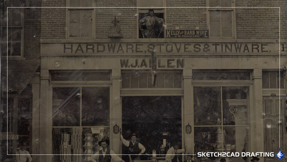
Photo courtesy of The Indiana Album from the David Yount Collection
The photo above, taken in the early 1800s, depicts 324 West Fifth Street. The current location corresponds to Ellie Mae’s Boutique store at 101 West Kirkwood Avenue, situated on the south side of the courthouse square. William John Allen operated this place of business as a hardware store in 1883 selling everything from cutlery to farm implements.
There was no Information recorded on the back of the original photo to identify anyone shown. However there are many individuals depicted sitting, standing, and even a gentleman in the central window with his hands on the support cables to the hanging sidewalk signage. To the left would be the opposite end of Greeve’s & Son’s Grocery Store and the man under the canopy could possibly be one of the owners.
The gentleman standing closest to the street frontage is standing next to a hand cranked apple peeling machine with two wooden buckets on the shelf below. Directly behind there are steel wares along with what appears to be either stacked canned goods or story books on a rotating turnstile. If you look real close there’s also a large column and cap against the wall and another one seen more clearly on the opposite side in the window. A man standing with his arm against the limestone pilaster on the left side of the door is holding up the building (that’s a contractor joke) with a large cooking stove inside the building. To the right another man is holding up another pilaster talking to the main in chair. With the way these men were holding this building up it should stand for years! The first guy seated has his head blurred due to movement. The older cameras took longer for the film to expose and if you moved you looked like a ghost in the final developed film. The final two gentlemen are staring at the photographer unsure of his purpose. Behind these three men sitting, through the window there are additional items for sale that can be seen.
Above in the first window on the left there are items that are barely visible but could be glasses or cups on top with a cabinet to the side. I cannot identify what the item is directly above the hardware signage and to the left of the man in the window. It appears to be a large coffee pot attached to the brick of the building. To the right of the man in the window is a promotional sign for Kelly Steel Barb Wire stating it is the strongest & best.
Looking at both of these photos really puts everything into perspective. Many drive by the south side of the courthouse and never know about the buildings or people that formerly occupied them. The difference in the architecture of what was formerly there compared to today is amazing and a classic example of the architecture the city pushed so hard for back in the 2010’s.
1883 west side of the square

Photo courtesy of Indiana University Archives
This next block of buildings was referred to as the Mullikin Block. I will start at the alley just west of the corner and work back around as it pertains to the fire in 1883.
On March 16th, 1883, the townspeople were startled awake by the sound of a fire alarm. Flames erupted from the southeast cellar door beneath Kahn & Tennebaum’s clothing store, and within moments, the building was consumed. The blaze quickly reached the front of J.W. Shoemaker’s drugstore, leaving little time for any items to be rescued.
The fire spread rapidly westward from 307 South Fifth Street, curling around the intersection of Fifth and College and advancing up to the alley. Some business owners braved the inferno in hopes of salvaging their belongings, but most efforts were in vain. Though the fire department and locals worked valiantly to battle the flames and ensure no lives were lost, the structures themselves were destroyed. Many businesses were insured, yet some owners faced total loss with nothing to fall back on.
Summarizing this event, which was recounted in great detail across two lengthy newspaper articles, is no easy task. Capturing the richness and nuance of the original writing would require an hour to read in full.

1883 west side of the courthouse square
- 306 West Fifth Street
Kruegher’s Office - 307 West Fifth Street
Neeld’s Meat Shop (before fire)
Baldridge’s Grocery (before fire)
Matthews & Tourner Furniture (after fire) - Around the corner and heading north. The west side of the downtown courthouse square:
- 30 North College Avenue
Kahn & Tannenbaum Clothing on the ground floor (before fire)
Domareo’s Feed Store in the basement where the fire originated (before fire)
Queen City Clothing (after fire)
Queen City Barber Shop ran by Harry Imes & Willliam Proffit Basement (after fire) - 31 North College Avenue
J.W. Shoemaker’s “Boss” Drug Store (before fire)
W.T. Blair Boots & Shoes (after fire) - 32 North College Avenue
This structure was owned by Rodick Wylie. Tenants were McCalla Clothing before the fire & Dr. J.W. Crain’s Dental Office. After the fire McCalla returned to this location, but Dr. Crain relocated 329 East Fifth Street upstairs at the corner of 5th & Walnut. - 33 North College Avenue
A variation from the Sanborn Map. This building owned by Jerry Howe had to be split in two for all of the tenants to fit in here. Another issue is that it was called out on the map as a clothing store and H&C whatever that means, but the use wasn’t that. On the south end there was C.R. Purdue Boots & Shoes and he had a roller skating rink upstairs on the second floor. To the north of him was a structure owned by Dr. Maxwell and the tenant in the space was City Book Store owned by E.P. Cole. After the fire C.R. Purdue relocated to the south side of the courthouse square and Mose Kahn “Boss” Clothing occupied this structure.
- 34 North College Avenue
Structure was owned by Mrs. Watts, the businesses that occupied the building before and after the fire was Josh O. Howe Jr. Jeweler and American Express Agent. - 35 North College Avenue
Structure was owned by Rena Howe, some articles state Rena Burford. William P. Reed Harness & Saddlery occupied the structure prior to the fire and City Book Store (E.P.Cole) after the fire. - Alley
- 36 North College Avenue
The owner of the building was Peter Bowman who ran The Parlor Drug Store, its former tenants included Hiram Lindley, a pharmacist, Henry P. Tourner Watch Maker, and later J.S. Faris & Company. At the corner of the alley stood a small stand known as ‘The Trade Palace.
Later that year, Peter Bowman exchanged ownership for the small lot at the corner of the alley. After the lot was vacated due to a fire, he added an extension to ensure the building was uniform with the rest of the block. The room to the north was vacated by Bowman and would be the furniture store in the next listing. - 37 North College Avenue
William Baker & James Neeld Furniture (formerly on the north side with Stuart & McPheeters). There is no direct association with Baker & Neeld being on in the exact space other than it stated, on the north side of the square. While doing research on Benjamin Neeld years back, there was mention of his relatives doing business in the same space. More information on this individual building can be located here. - 38 North College Avenue
Boots & Shoes - 39 North College Avenue
George T. Atkinson Boots & Shoes ground floor
Barnes & Lewis Photography on the second floor - 40 North College Avenue
Jeweler - 41 North College Avenue
Boots & Shoes - 42 North College Avenue
John W. Davis Merchant Tailor
1907 Courthouse Square Bloomington, Indiana
While these next images are not from 1883, they give a better sense on what the former courthouse square looked like in 1907 which many of the building from 1883 still stood. The original images from the archives were broken up to make them easier to follow along with and understand.

Photo courtesy of Indiana University Archives
This image is standing on Fifth Street/Kirkwood Avenue looking west just before the at the intersection of Walnut Street. On the right you can see the south side of the courthouse square and in the far distance the west side of the square. Along the sidewalks at the edge, street lamps with triple globe are shown with none at the perimeter of the courthouse.

Photo courtesy of Indiana University Archives
Unlike the previous photo, this one pulls back to show more of Fifth Street and Kirkwood Avenue. On the right, a man leans against the building known as “Old Farmer’s Corner.” Directly across from him is “Greeve’s Corner,” which you can identify by its wide sidewalk. A closer look reveals that this photo includes street lamps at the courthouse that weren’t present in the other image. This indicates that while both photos are from 1907, they were captured at different moments.

Photo courtesy of Indiana University Archives
Standing at on Walnut Street looking to the north just before the intersection of Fifth Street/Kirkwood Avenue. To the right is “Old Farmer’s Corner” where the bank building stands and the courthouse on the left. In the far is the north side of the square at “Old Harryman Corner”. The second building to the left is the Stuart & McPheeter’s building indicated by the raised central parapet.

Photo courtesy of Indiana University Archives
Jumping up to Sixth Street, this view is looking west just back from the intersection of Walnut Street. To the right is 124 North Walnut Street, former location of the Walnut Street Hotel. The shadows on the ground indicate that these photos were taken in the early morning hours of the day. To the right across Walnut Street is “Old Harryman Corner” with the first building showing the painted building signage on the Urmey & Kinser building. Next door is Stuart & McPheeters and in the far distance the Bowles Hotel on the right side corner.

Photo courtesy of Indiana University Archives
Over on College Avenue, this view is looking south just back from the intersection of Sixth Street. As with the previous photo on Fifth Street, this photo does not have the lamp posts along the courthouse sidewalk area. To the right of the intersection at the first shown lamp, this was called the “Progress Block”.

Photo courtesy of Indiana University Archives
Finally to complete our walk-around the square is the second image of the previous photo pulled back a little, only this time we have the lights around the courthouse sidewalk area. To the left is the Breeden Store indicated by the signage. Notice the metal access ladder attached to the brick structure and the stretched oval window above the signage. Another item to point out over here is the steps down from the sidewalk to the road, there was no consideration for accessibility back then. Across College Avenue the covered entrance with piers to the Bowles Hotel is shown.
2025 Courthouse Square Bloomington, Indiana
A lot can change in over a century. The following series of photos were recently took in 2025, hoping to mirror the exact views captured back in 1891. This proved more difficult than anticipated. The most significant obstacle was the structural dome of the Monroe County Courthouse, which has reshaped the town’s skyline and blocked the original perspectives. Additionally, a century of ever-changing city restrictions and requirements for landscaping has led to abundant tree foliage, often hiding the intricate details of current building facades. Comparing these modern views with their historical counterparts provides a fascinating look at the town’s evolution, especially its notable progression “upward.” All photos were provided by Gabriel Wheeler.
2025 north side of the square

A view on the north side of the courthouse square along Sixth Street looking northwest at College Avenue on the left side.

A view on the north side of the courthouse square along Sixth Street looking northeast at Walnut Street on the right side.
2025 east side of the square

A view on the east side of the courthouse square along Walnut Street looking northeast at East Sixth Street on the left side.

A view on the east side of the courthouse square along Walnut Street looking southeast at Kirkwood Avenue on the right side.
2025 south side of the square

A view on the south side of the courthouse square along Kirkwood Avenue looking southeast at Walnut Street on the left side.

A view on the south side of the courthouse square along Kirkwood Avenue looking southwest at College Avenue on the right side.
2025 west side of the square

A view on the west side of the courthouse square along College Avenue looking southwest at Fifth Street on the left side.

A view on the west side of the courthouse square along College Avenue looking northwest at West Sixth Street on the right side.
In closing, while these images and records provide a snapshot of the past, they also highlight a crucial lesson: the history of a place like Courthouse Square is never truly finished. It’s a living story, continuously shaped by the buildings that rise and fall, the businesses that come and go, and the people who walk its streets. By documenting these changes, we can better appreciate the progress and preserve the memory of the town’s earlier days.